by Larry
June, 2016Crossing the DeepOnly much later has there come to be appreciation for the skill possessed by the first Pacific islanders in crossing vast stretches of sea. Even into the 20th Century, some anthropologists assumed their migrations were sort of like the spread of infection, a random dispersal, maybe on craft that could simply drift and perhaps as local populations had become too large, rather than intentional navigation achieved without instruments. This view might have persisted, for most ancient Pacific navigational lore was dying out, except that a few decades ago, one individual, a Micronesian named Mau Piailug, was found who still knew how to cross vast distances in the old ways. He gave the talent to a younger man, Nainoa Thompson, who in turn has taught a new generation. The story of this mentoring and voyaging is dramatically and beautifully told in PBS documentaries titled: "Wayfinders: A Pacific Odyssey," available in VHS (1998, PBS.org) and "Wayfinders: A Pacific Odyssey Hawaii," DVD (2016, from PBS.org).
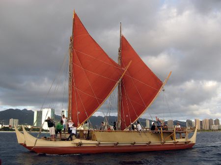
There was great rejoicing and enthusiasm among over 17,000 people at Pape'ete Harbor, Tahiti, when Hokule'a made it, completing the first leg of the round-trip voyage. The finishing of the circuit back to Hawaii seems to have sparked a resurgence of interest in other ancient traditions and skills among indigenous peoples. Since that initial Hokule'a open-ocean feat, Nainoa Thompson has made several other non-instrument sea voyages. He now has been the mentor himself, teaching younger people the old navigation methods. He has covered many thousands of miles passing on the art of ocean wayfinding. Those techniques almost defy conventional understandings of the limits of the human mind and body. A wayfinder navigator uses the stars, the feel of waves crossing under the vessel's hull, the look of the horizon at sunrise, wind patterns, sightings and behaviors of birds, and even an occasional sensing of the moon at night, though obscured behind dark clouds, to determine how far and in what direction the craft has come and where it is in relation to its destination. Navigators must be awake more than 20 hours a day, usually standing so as to best feel the movement of the deep. Progress must even be sensed during brief catnaps, so that all that has been memorized about the voyage to that point is not lost. This type of travel is hardly without risk. On several occasions, non-instrument navigators have doubted themselves, have even made significant mistakes, only to have the guidance of a more expereinced person, some fresh bit of data from nature, or a just-in-time intuition get them back on track. There are of course other hazards as well. In a big storm, the vessel capsized on one occasion. One of the crew left to seek help and died, though those who had remained behind were rescued. Wayfinders point out that islands that have been home for their people for hundreds or thousands of years will be disappearing as sea levels rise. In contrast to the new ways, their ancient connections with nature and the deep were sustainable. Those most responsible for these changes are from places far from the populations to be first affected. Perhaps those distant folk can learn something from a people who collectively have been skilled navigators upon the open oceans for tens of millennia. Our deepest inner explorations might illumine the voyages now needed as we seek to navigate external reality's greatest challenges. In May, 2014, Hokule'a commenced a more than three-year, 47,000 mile 'round-the-world passage. Last month, it arrived in Washington, D.C., on the Potomac. From there its crew hopes to take it to Newfoundland, then down the St. Lawrence Seaway to the Great Lakes, and finally back southward and, once through the Panama Canal, westward and home again to Hawaii. After this, only those age 32 and below will be permitted on the next voyages. Carrying on the tradition of non-instrument navigation, this newest generation of adventurers will include both genders. |
